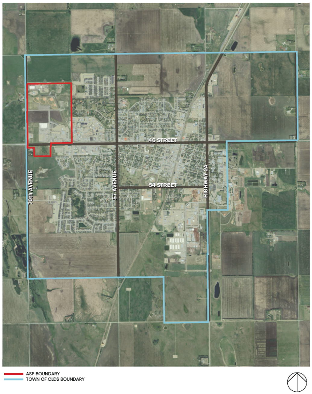
Cornerstone Area Structure Plan

An Area Structure Plan (ASP) provides a framework for subdivision and development on a given piece of land. Within Olds, ASPs are typically prepared for quarter sections of land to show future uses and the general location of roadways.

Cornerstone Area Structure Plan (2016-33)

Long Sky Lands - Proposed Cornerstone ASP Amendment

The Long Sky Lands are three parcels totalling roughly 60 acres in northwest Olds. They sit along Cornerstone Road and 67A Avenue, just north of the Highway 27 shopping district and next to Rotary Athletic Park. Much of the groundwork is already done: roads are in place and two of the parcels are graded with utility services at the property line, making them some of the most development-ready land in town. The previous landowner was Long Sky Developments Ltd., hence the name.

In 2016, the Town and Long Sky Development signed an agreement that saw the Town invest roughly $2.9 million to build the roads and underground services that support the Long Sky Lands. That amount was to be repaid by the landowner as the lands developed. 

The Town’s rationale was to facilitate the construction of Rotary Athletic Park, which could not have been built without the associated infrastructure built through the Long Sky Lands.  

But development of these parcels never moved forward, and market conditions made it difficult for the owner to find a buyer at a price that covered what was owed to the Town, leaving the lands sitting idle and the Town's infrastructure investment unrecovered.

On April 27, 2026, after several years of working with the landowner and potential buyers, Council directed administration to finalize an agreement with Long Sky Developments Ltd. Under that agreement, the owner transferred all three parcels to the Town in exchange for forgiveness of the outstanding servicing costs and interest, and the Town accepted the lands in their current condition. The Town now holds title.

The Town recorded an allowance in its 2025 audited financial statements to reflect the land’s current market value. This means the financial impact has already been accounted for. Taking ownership of the lands in 2026 did not involve a cash purchase or new borrowing. Instead of an uncollectable debt, the Town now holds roughly 60 acres of serviced land it can sell to recoup its initial investment.

The Town does not plan to hold these lands long term. The goal is to get them developed and recover the Town's investment. Proceeds from future sales will return to the Town, and developers will still be responsible for off-site levies that help fund infrastructure serving the area.  

But the first step is updating the Cornerstone Area Structure Plan, which currently reflects planning from 2017. The proposed update supports a wider range of housing, such as townhomes, seniors-oriented housing and rental options, along with mixed-use development along Cornerstone Road, height transitions next to existing homes, and connected parks and pathways. Once the plan is updated, the Town intends to offer the lands to private developers through an open, competitive process.

1st Reading of the Cornerstone ASP Amendment was given on September 14 and a public hearing is scheduled for October 13, 2026 at 1:00pm in Town Council Chambers.  

For further information, please see: 

Cornerstone Public Hearing Questions and Answers

Thank you to everyone who wrote to Council, spoke at, and attended the public hearing on October 13. The information below attempts to provide written answers to the questions we heard.

The short version: Bylaw 2026-29 updates a long-range plan for the Cornerstone area. It does not rezone any land. Nothing new can be built here until the land is rezoned through a Land Use Bylaw (LUB) amendment, where Council would need to hold a separate public hearing, with notice to nearby residents.

SCHEDULED PUBLIC HEARING REGARDING PROPOSED BYLAW NO. 2026-29

Bylaw No. 2026-29 proposes broad amendments the Cornerstone Area Structure Plan. Changes include an updated Land Use Concept with more mixed-use and medium- to high-density residential development, as well as expanding the area of the plan to include some land south of Highway 27 that is not currently part of an Area Structure Plan.

A public hearing regarding the proposed bylaw was held on Tuesday, October 13, 2026, at 1:00 PM in the Council Chambers at the Olds Municipal Centre. The style of the hearing was informal and persons wishing to speak were requested to state their name and address for the record upon being recognized by the Chair. Council heard submissions made in person or by the agent from any person who claimed to be affected by the proposed bylaw. Any person wishing to submit written comments were welcome to so by sending them to the Town of Olds Planning and Development department prior to the hearing. Persons could make oral presentations in person or virtually via Teams at the Council meeting, regardless of whether or not they had provided written comments.

Draft Bylaw 2026-29

Draft Bylaw 2026-29 Schedule A

An area structure plan (ASP) is a long-range guide for how an undeveloped area of town may grow over 20 years or more. It shows where homes, businesses, parks, roads and pathways could go. It does not give anyone permission to build.

The Cornerstone Area Structure Plan was first approved in 2017. Bylaw 2026-29 updates it to reflect current conditions, including the closure of the old waste transfer station and the former sewage treatment site.

No. Zoning is the set of rules that says what can be built on a piece of land. The zoning on these lands is not changing.

All three Town-owned parcels stay zoned Future Urban District. Any future rezoning would need its own bylaw.

Full details can be found in the Town’s Land Use Bylaw here, but in summary:

  • Future Urban District (FUD): A holding zone that keeps land undeveloped until Council approves another zoning for it. Only parks and sheds or similar buildings for existing uses are permitted. Farming, utilities and temporary buildings are allowable uses but require Council approval. No new homes or Town of Olds, October 16th, 2026 businesses can be built. All three Town-owned Cornerstone parcels are zoned FUD today.
  • Traditional Neighbourhood District (RTD): A residential zone for single homes, side-by-side homes (duplexes) and townhouses, with basement, garage or garden suites allowed. This is commonly referred to as “low density” zoning.
  • Mixed Use Node (MUN): A zone that mixes homes and businesses, often with shops on the main floor and apartments above. Permitted uses include apartment buildings, townhouses, duplexes, cafés, small shops, child care and small health clinics. MUN is commonly referred to as “medium density” or “high
    density” zoning.

No developer has been chosen, and no pending deal is behind this plan’s update.

The land was planned for development by its private owner, Long Sky Developments, as part of the 2017 Cornerstone Area Structure Plan.

In 2016, the Town paid to build the roads and underground water and sewer lines that serve the area. In return, the owner agreed to repay its share of those costs (about $2.9 million) once the land was developed.

The land never developed. The owner tried for several years to sell it but was unsuccessful. That left a real risk that the land would sit empty for many years, and the Town would never recover its investment nor see development occur.

In 2026, Council approved an agreement for the owner to transfer the land to the Town in exchange for cancelling the amount owed. The Town now owns about 60 acres across the three parcels. The Town plans to sell the land to builders to recover its investment and bring new homes and businesses to Olds.

The Town intends to sell the land at market value, based on an independent professional appraisal. Interested purchasers will submit proposals, and the Town will consider the offer price, builder experience, and how soon they plan to build.

Town of Olds, October 16, 2026 If the Town considered selling land for less than market value, provincial law
requires that to be publicly advertised first.

Most of the future Cornerstone area is planned for low to medium density homes, such as single homes, duplexes and townhouses. The land behind Walmart is the one spot with few neighbours: shopping to the south, the Town boundary to the west, and Rotary Park to the north.

Placing apartments next to shopping is common planning practice. Residents can walk to stores and services, which means fewer and shorter car trips. Traffic studies show an apartment home creates fewer daily car trips than a single-family home. The 2017 plan already encouraged higher density next to the shopping
centre, so this is not a new idea.

If the land is rezoned in the future, the plan supports two kinds of zoning:

  • East of 67A Avenue, neighbourhood residential zoning (Traditional Neighbourhood District or RTD). This allows single homes, side-by-side homes (duplexes) and townhouses. Small buildings with up to four homes may be allowed with Council approval.
  • West of 67A Avenue and along 40 Street (Cornerstone  Road), mixed-use zoning (Mixed-Use Node or MUN). This allows all of the above, plus apartment buildings and buildings with shops on the main floor and homes above.

If the land is rezoned in the future, height limits would depend on the zoning approved:

  • Neighbourhood residential zoning (RTD): up to 12 metres (~3 stories).
  • Mixed-use zoning (MUN): up to 25 metres (~ 6 stories).

The Town relies on independent studies, including the 2025 Housing Needs Assessment and the Province of Alberta's annual Apartment Vacancy and Rental Cost Survey. These informed the Town's first Housing Strategy, adopted in 2025.

However, the Town does not decide how many homes get built. Demand in Olds is market driven, and while we try to measure that market, it is ultimately a decision of private builders what to build, and how fast, based on what people want to buy or rent.

Based on feedback received, the next draft of the Cornerstone ASP will include a height limit for new buildings next to existing homes. Assuming Council approves this amendment, future properties immediately north of existing duplexes will be limited to 2 stories in height.

No. Because of a major sanitary line running underneath the berm, the Town will require permanent access. However, this means there will be a green space buffer between existing homes to the south and future homes to the north. The type of buffer has not yet been determined and would be part of the development stage. The Town will engage with affected landowners when that time comes.

The Town's Land Use Bylaw sets a minimum number of parking stalls for every type of building. This plan update does not change those requirements. 

A builder who wants to provide fewer stalls than the rules require must apply for permission (called a variance) and explain why. Requests to reduce parking by more than 15% must go to Council for a decision.

In some parts of town, builders can pay the Town instead of building parking onsite (called cash-in-lieu). That option is only available in Uptowne and East Olds, not in the Cornerstone area.

Additional traffic is expected as the area grows and the Town is planning so that 67A Avenue does not become the only primary route in and out. 

In the short term, the plan includes new access points at Cornerstone Road. These give new homes and businesses direct routes to Cornerstone Road and Highway 27 without passing through existing neighbourhoods and the commercial area.

In the long term, a new road connection to the north, into the Vistas community, will give residents another way in and out of the area. This spreads traffic across several roads instead of concentrating it on one.
Other steps will include:

  • Update the existing traffic impact assessment, so impacts on 67A Avenue are measured before any development is approved.
  • Count traffic on 67A Avenue before and after each phase of development, and adding measures such as signs, crosswalks or parking limits if they’re needed.
  • Work with Alberta Transportation on improvements to the Highway 27 intersection at 67A Avnue.

Because the land will be developed gradually over many years, traffic will grow slowly, and the Town believes it will have time to monitor and respond appropriately.

The speed bumps were installed as a temporary measure while these roads are bordered by empty land. As development occurs, the Town intends to remove these speed bumps along Cornerstone Road and its portion of 67A.

In both the RTD and MUN zones, some uses are allowed automatically if they meet the rules, while others need Council approval first, with notice to neighbours. Town of Olds, October 16th, 2026 RTD or Neighbourhood residential zoning (east of 67A Avenue):

All businesses here need Council approval and are limited to:

  • a cafe or bistro
  • a residential care home
  • small shops and services up to 300 square metres

MUN, or Mixed-use zoning (west of 67A Avenue and along Cornerstone Road). A wider range is allowed, including:

  • cafes and bistros
  • care facilities
  • small health clinics
  • offices
  • places of worship
  • shops and services, small to mid-sized (up to 2,000 square metres)
  • liquor and cannabis stores (not within 100m of a school or park)

In the MUN district, businesses such as animal services (e.g., vet or groomer), car wash, funeral home, adult entertainment, and gas stations, require Council approval.

All residential zones also allow home-based businesses, such as a hairdresser or bookkeeper working from home.

Town administration is drafting an updated document, based on initial feedback, for Council’s consideration. We expect Council to consider this amended draft on October 26th and final reading is expected to be considered by November 9th.

We don’t know for sure, as the housing market is hard to predict. But in a community the size of Olds, an area like this can take 20 years or more to fully build out. Land closest to existing roads and water and sewer lines is likely to develop first.

Yes. Before anything is built, a builder must go through these steps, in order:

  1. Rezoning. The builder applies to change the zoning via a Land Use Bylaw Amendment. Council holds a public hearing, nearby residents are notified, and anyone can write to Council or speak.
  2. Subdivision. The land is divided into lots, roads, and municipal reserve.
  3. Development permits. The builder applies to build a specific project. Neighbours are notified where the rules require it and can appeal some decisions made by the Town to the Subdivision and Development Appeal Board (SDAB).

Please contact the Town’s planning department via email (planning@olds.ca) or by phone (403-507-4806). You can also reach out to a councillor directly; contact details are available on the Town’s website.

Contact Us

Town of Olds
3501 70 Avenue
Olds, Alberta, Canada
T4H 1L7

Phone: 403-556-6981
Email: admin@olds.ca

Sign up to receive News & Notices

Stay up to date on the city's activities, events, programs and operations by subscribing to our eNewsletters.